Zion Traverse
A tale of beauty and the pain of long distances


This is not about software or work and it will be a long read; hopefully it’s an interesting read - in the event you want to do the Zions Traverse or understand how I undertake attempts at long distance events on trails however mostly it’s an opportunity for me to reflect. For sure its a record of why in the last half of my career I didn’t feel afraid of anything at work.
Seth wanted to do a 50k before he turned 50. Like all feats of endurance it’s part of a curiosity about whether you can. Added to that is the opportunity to explore beautiful countryside along the way with good friends.
Originally we were gonna tackle Rim to Rim to Rim on the Grand Canyon, but the fire and the North Rim closure shut that down. Spring was our timeframe and so I turned to other south western destinations where we could take advantage of good weather - warm but hopefully not too hot.
I have had my eye on the Zion Traverse of Zion’s National Park (ZNP) for a while and mapped out the route. Originally Seth had wanted to do 50 miles but readjusted for a 50k and the Zion Traverse checked that box at around 60k. The traverse starts at Kolob Canyon - the far western side of Zions about 20 miles south of Cedar City and makes its way south westerly through canyons and over open country to the White Rim and down past the infamous Angels Landing to the park’s main road.

Logistics
The logistics of a point to point traverse always require coordination. Someone to drop you off and some way to have a car or someone to pick you up at the end. The driving distance between the start and the finish is only an hour - but if your aiming to have a car at the finish you have to drive all the way into ZNP first and then back track. Bureaucracy and regulations make this tricky. The main road into ZNP closes to cars every spring and fall and transportation is limited to shuttle busses. The last shuttle leaves the park at 7:15 pm - so if you don’t make that - you have another 5-6 miles out of the park into town. There is a lodge in the park, that is only .6 miles from the end of the trail but rooms are hard to come by, though I got lucky to catch a cancellation for the night our journey would complete. Staying at the Lodge does give you a code that lets you open the gate and drive to the Lodge. HOWEVER - if you happen to need to park a car at the Lodge the day prior to your arrival - they refuse to give you a parking pass, because you can of course only get a parking pass for the day you are checking in. We needed to leave a car there on the day before. The Lodge refused to budge and said we should ask the rangers for a yellow permit that they give to climbers who are driving in - parking and climbing. However the rangers said because we were not actually entering the park from the eastern side and were starting at the western side we didn’t qualify for a permit. They wouldn’t issue one to just drive in and leave a car.
Bureaucracy and regulations will never bend to the law of common sense. Between a rock and a hard place - Since we wouldn’t have a car when we arrived I drove into the Lodge to drop off bags so we’d have fresh clothes to change into. Only to be informed by the Lodge that they didn’t check bags as a matter of policy. Though a nice lady at front advocated for us and did in fact check out bags. As I filled out the bag tags - I apologized because I had 3 bags - she replied “Oh its ok, since we don’t take bags it doesn’t matter to me how many you check.” :)
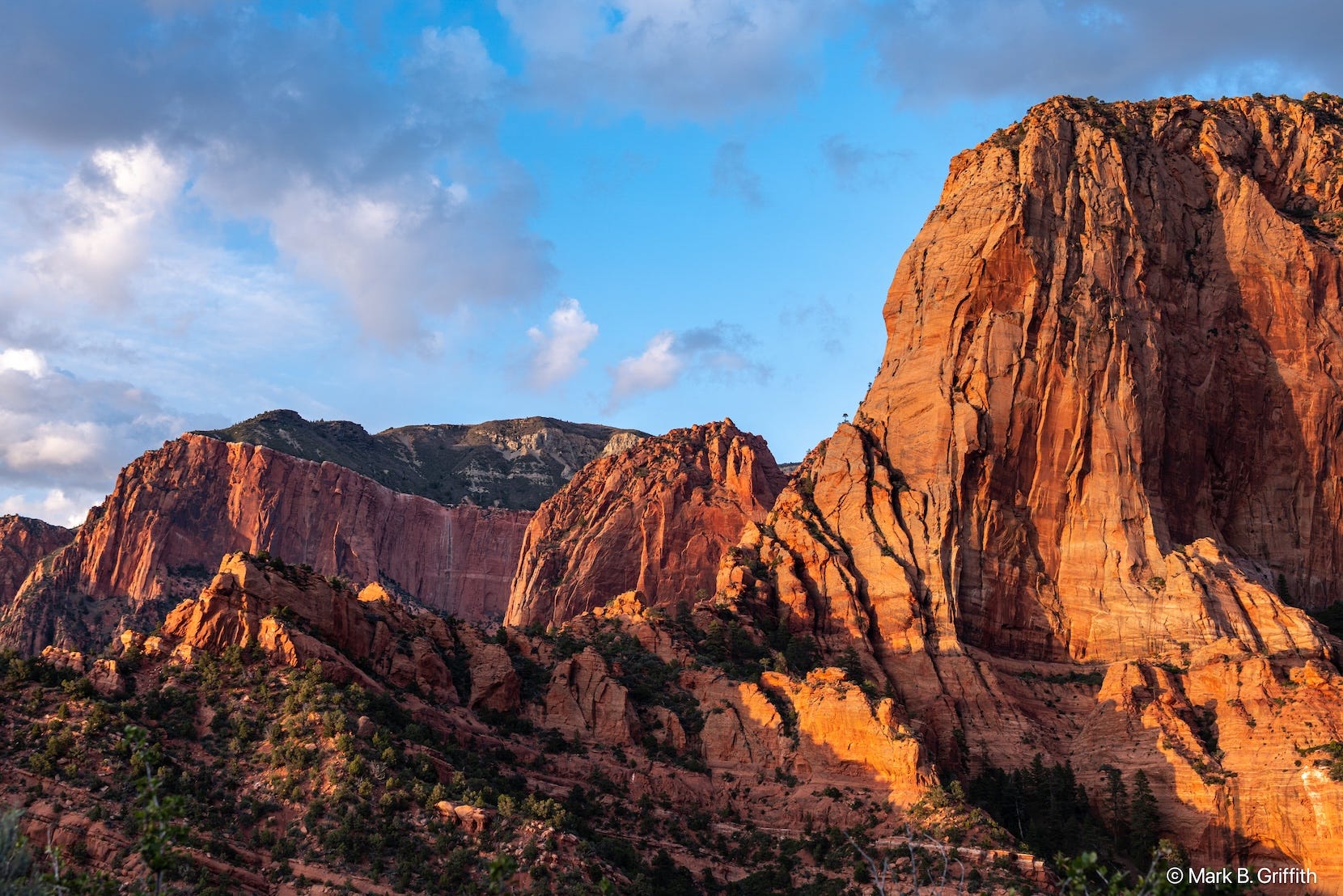
I drove back out to meet Seth at the visitor center where he’d acquired our valid wilderness permit to enter at Lees Pass and traverse the park and we set out for the hour drive to the trail head. We were both blown away by how amazing the towering red rock formations were in Kolob Canyon - and its only a 3 minute drive off the freeway - well worth the stop! Our plan was to camp at the trailhead and then start out early Tuesday morning. Of course the park doesn’t allow you to sleep in your car or camp at the trail head - regulations again! We managed to find a flat spot up the hill out of sight and laid out our pads and bags to cowboy camp. After watching a memorable sunset fade across the red rocks that only glow even more red in the waning light - we went to bed pretty early. I fell asleep immediately but woke up around midnight for the old man pee. The moon was more than 3/4s full and was so bright. I did not sleep well - I kept waking up - not because I was worried or anxious or even that I was cold but just kept waking up. I’d read some (The Rush), played a game or listened to a podcast until I fell back asleep only to wake back up some time later. Finally at 4:30 am I was starting to feel the cold and I had to pee again - so at 4:45 am I yelled at Seth that I was getting up.
We packed up and wandered back down to the car to make some breakfast (greek yogurt, granola and raspberries) and get our packs together.
What I packed
My favorite long distance (non-overnight) running pack was the Ultimate Direction Mountain Vest V4, sadly that pack broke when I was testing things out Sunday (the vest sides have four “ropes” that tie to a back support and those ropes broke - I was/am sad). So I ended up using a smaller UD Mountain Vest of the same pack that lacked the side pouches and the back kangaroo pouch. Years ago I’d had Shon Hancock sew some side pockets on. The pack is about 12 liters with a main pouch and the typical shoulder straps for bottles and gels. I had about 1500 calories in the front and side pockets. I had a first aid kit - all custom bits with a pair of scissors and a wide variety of adhesive tape materials from bandaids to moleskin to deal with cuts, chaffing and blisters. I had a bag of bottles - a Katadyn BeFree bottle with a carbon filter, and 2 other 1 liter bottles and one 650 mil flask. All of these bottles have the Hydrapak lids that have the open/close valve function (not sure why every flask doesn’t have these now). My two bottles for the front of the vest were the UD 500 ml flasks, because nothing else really fits in the vest but those flasks (they need to be short squatty vs long skinny). I started out with the front flasks full of water and about 500 ml in the 650 ml flask with Scratch lemon-lime. For shoes I wore the Brooks Cascadia Pro (a mistake I’ll talk about later), Darn Tough socks, Path Projects liner shorts (which also failed but in an expected way but just unfortunate timing - more on that later too), a pair of Patagonia running shorts with the liner cut out (since they always wear out), a Naked running belt, a short sleeve light weight wool shirt, OR Sleeves, a Black Diamond Distance LT Hat that is light and breathable with mesh side panels and a pair of Ombraz sunglasses (which solve a problem that I never really had a problem with : sunglasses with side arms). And over that I wore a Patagonia Houdini to keep me warm, by far my most used/favorite bit of kit (as the Brits would say). My watch was a Coros Vertix and I wore the Coros heart rate monitor on my arm.
I also had 4 cameras - 2 film cameras - small compacts - Minolta TC-1 with a roll of Kodak Porta 800, and Olympus Stylus Epic with a roll of Kodak Porta 400. The always versatile Sony RX100VII - that has the best quality to size ratio of a point and shoot (f/2.8 24-200mm lens - I just wish they’d come out with the RX100VII already its been since 2019!) and finally a GoPro 13 on a flexi pod. I had both the GoPro, the RX100 and the 650 ml bottle stuffed in my running belt and one film camera was in a front pouch and one was in the vest back. (Started out at ISO 800 for lower light, and then switched to ISO 400 during the day). I kept my iPhone in my vest’s side pouch and I also had a Garmin Mini that was tracking my position and that I could send satellite text messages to my wife. And I carried with me two foldable Black Diamond Z-poles.


Lastly - I had 3600 calories in the form of gels and bars. As noted I started out with about half in vest pouches and side pockets and had the other half stuffed in a sack in the bottom of the pack. My favorites are the Salty Peanut Power Gel, then the Huma gels. I like the Quantum Energy Squares because they are quite salty/savory vs. being too sweet. I had some Trail Butters and a couple of peanut Enervit C2:1PRO bars (which I did not like) and 2 big Precision Fuel PF 90 Gels which had 360 carbs. I found the one humongous Precision gel I ate to be absolutely disgusting; they are supposed to be “palate fatigue” resistant by not having a flavor but they tasted slightly sweet and had the consistency of starchy runny glue, probably didn’t help that when I took a hit - I squeezed a HUGE mouthful in but I gagged it down. I never got to the other one as it dropped to the bottom of the list - and it was so big it triggered a bag search at airport security coming home (but not going?) and I abandoned that gel to the garbage bin. I also had 6 bags of 1.5 scoops of lemon lime Scratch Hydration mix with 120 calories) and I ended up consuming 5 of those bags. (More on water later).
Thoughts as we set out
Seth had expressed some low grade anxiety about how he’d do on the distance - since this would be the farthest he’d ever gone; though he’d been training by running consistently before work - getting in the vert - though not as many long days due to work and life commitments.
I was pushing right up to the brink of cancelling. I retired at the end of January - and with the extra time I’d been chopping some huge Doug Fir rounds, hauling them into place and I cut down a 25 foot - 6 limbed large bush/tree that was always dumping leaves everywhere and hauled the branches to the back forty (they were really heavy due to all the water the wood carried) combined with the usual scrambling over blow downs, walking on fallen logs and jumping off. In the midst of all of that I strained my right quad - just above the knee - and it felt like a dull ache deep in my quad - when going downhill or doing up hill running with explosive push off. This took a long time to rehab - like 6+ weeks of PT and biking and my last test before going to Utah was just 2 different 60 minute runs on Monday and Friday in between biking to make sure I could run pain free. Those had been a success but I was nervous about whether or not the quad would hold up. I also had an issue - that I had off and on for years - where I get a nerve pain in the metatarsal of my left foot (the foot pad just behind the toes) and it lately had been bugging me again and I had mostly (re)figured out that I was irritating it because I had a tendency to tighten my shoes and as my feet swelled it pinched my toes and caused this nerve pain. So I wasn’t coming in exactly 100% healthy. And when your coming off an injury - your hyper focused on the injury area. Always checking in with your body to see what’s happening there. Is that pain? Is that phantom pain? Is that ache indicative of a problem?
In a spirit of inspiration I’d written out this mantra and sent to Seth :
We are blessed to be here; to be present for this moment; to be allowed and to be able to traverse this beautiful canyon country. May our hearts lift us, May our feet carry us; and with eyes up may we take in the world around us as we pass through. Start easy; finish strong. Forward is a pace in this beautiful place.
Section 1 : Lees Pass to La Verkin Creek (Mile 1-7)
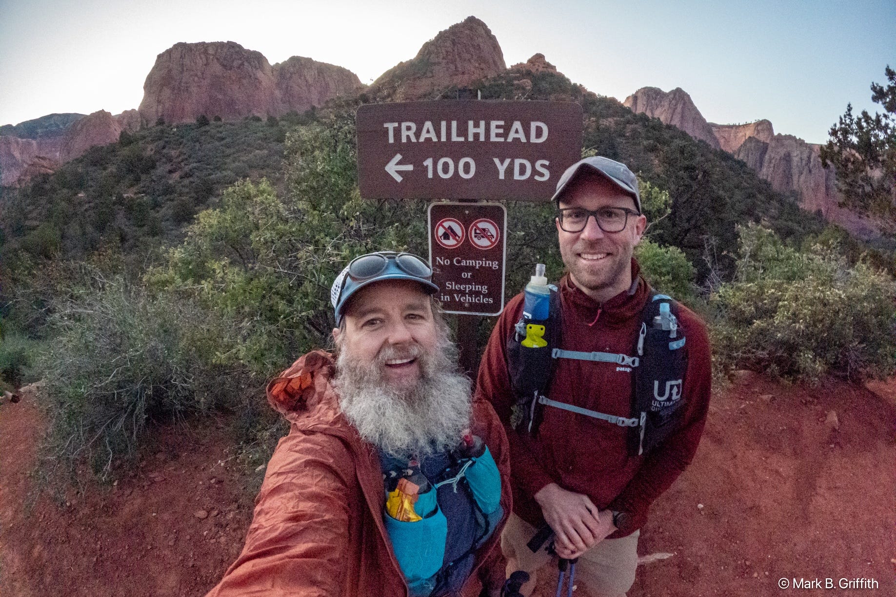
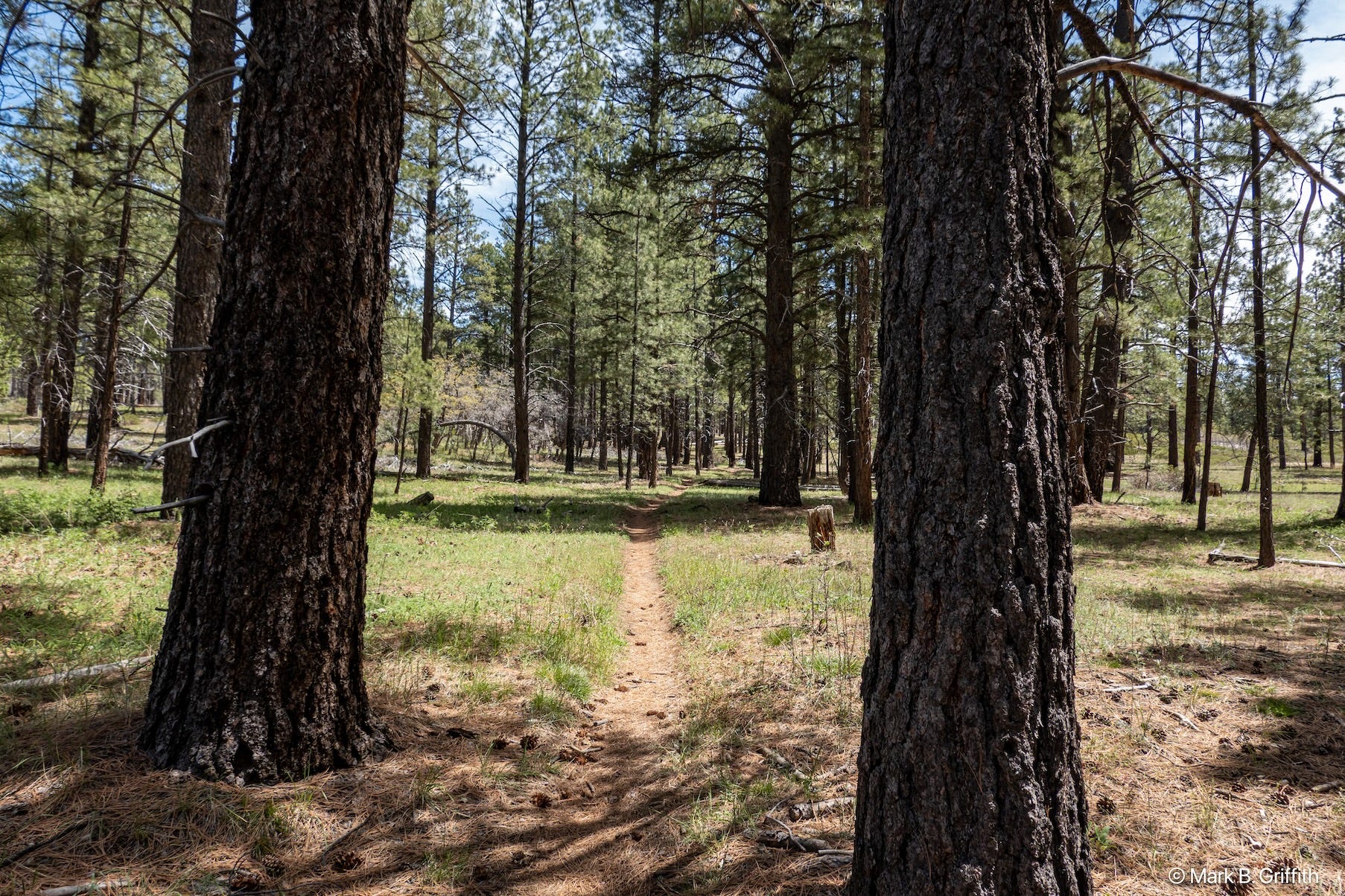
We got our packs together at the car at the trail head and set out around 6:30 am. The air was cold but just enough to chill your fingers. The trail starts out by dropping down from the road about 500 feet to Timber Creek, and then continues to follow this creek and descend another 500 feet, until at around 4 miles the trail bends around the large Gregory butte and starts a gradual ascent up the La Verkin Creek. Both of these trails are classic southern Utah desert canyons where water is plentiful : creek bottoms lined with grasses and full of rushes and bushes and dotted with large Cottonwoods - which were bright green in the spring and full of morning light dappling through the leaves.

At mile 7, just past the side trail to the Kolob Arch view point - the trail splits. The La Verkin creek trail continues up the creek on the left (east side) but you cross the creek and this starts the Hop Valley Trail - and here you find a consistent “good water” source : Beatty Spring.
Considerations of Water

Water in the desert is always a consideration - usually it is about whether there is water at all - and then if the water is there how to ensure that it doesn’t make you sick. Most illness from water comes from bacteria. In Zion, there is a new issue that is (impossible?) to get rid of. In many of Zion’s streams there is a bacteria that grows on the riverbeds - this is kind of like the pond scum you see growing on top of water but this is a benthic cyanobacteria. Benthic means “bottom-dwelling.” and cyano means dark blue. These bacteria don’t float but live in a “carpet” attached to the riverbed, rocks, pebbles, and submerged logs. The water flowing over them can look crystal clear. And the bacteria is sometimes green, but often velvety brown, tan, or black crusts. People often mistake this bacteria for harmless river silt or dark mineral deposits on the rocks. The issue is that its not the bacteria itself that makes you sick but that it produces a nuerotoxin (Anatoxin-a) - which is a chemical - not a living organism. They are in a family of Cyanotoxin’s similar to the venom in snakes, spiders, or scorpions. Neurotoxins, attack the nervous system by binding to your nerve receptors, but unlike good neurotransmitters they don’t “let go.” This causes permanent “on” signals to your muscles - essentially ‘hijacking’ the communication between your brain and your muscles. Resulting in tingling, numbness, muscle twitching, slurred speech, and in extreme cases, respiratory failure.
Treatment - There is none (not portable)
This neurotoxin (anatoxin-a) is not a bacteria - it is a molecule - i.e. chemical - it dissolves in water. Standard filters have 0.1-micron holes and are designed to catch bacteria (which are about 1-5 microns). The anatoxin-a is a molecule, approximately 0.0008 to 0.001 microns or a 1,000 times smaller than the pores in those filters.
The only way to remove these neurotoxins from water, is not to filter (which is mechanical) but instead you need to chemically destroy the molecule or “absorb” it. One “absorption” method is using activated carbon, which a high-grade carbon that has been “activated” by high heat, which creates millions of tiny internal pores. This gives activated carbon a massive surface area—one gram of activated carbon has the surface area of several football fields. Activated carbon works through adsorption (with a d), a process where toxin molecules chemically bind to the carbon’s surface like lint to Velcro. However, this is not an instant process. It requires significant contact time (often 10–15 minutes) for the molecules to find and latch onto a binding site. Portable water filters, which quickly force water through small carbon filters lack the necessary contact time and carbon volume to reliably remove dissolved neurotoxins like Anatoxin-a. Commercial water treatment plants let water slowly seep through large activated carbon for 10-15 minutes.
And don’t mistakenly think that boiling will help - which doesn’t “kill it” because its not alive, its not a bacteria nor does it breakdown the neurotoxin - it just concentrates it in the water - making it more dangerous. Same goes for chlorine tablets - which again kill bacteria, but aren’t strong enough to destroy cyanotoxins at standard doses. Municipal plants use much higher concentrations and longer “dwell times” to achieve this.
Don’t drink the water - there is toxin in the water
So that means you need to find reliable clean water that is not infected with cyanobacteria - you should always consult the Park’s website for current reports - (big floods and water flow can remove the cyanobacteria and result in safe water conditions).
But back to the report - Beatty Creek is across the creek on the right hand side of Hop Valley trail - seeping out of the hillside right at mile 7 and is often the last good “guaranteed” water source until Cabin Spring at mile 32.5 (25 miles away!) - there are a few other springs that may or may not be flowing depending on conditions : Wildcat Springs at mile 21, Potato Hollow at mile 28 or, Sawmill Springs (off a side trail) at mile 23.5. We drank our fill at Beatty and filled up 3 liters each. I remixed another liter with Scratch hydration mix. And then we started up the Hop Valley Trail.
Hop Valley - 7 Miles of Beauty and Soul Sucking Sand (Mile 7-14)
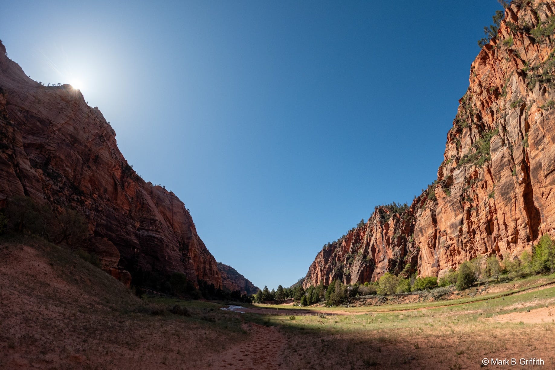
The Hop Valley trail starts out with a 1 mile punchy 600 ft climb to the top of the ridge at 5900 ft above sea level. Since I live at 600 feet - on any steep climb I would feel the elevation and my breathing would become more ragged. A short half-mile descent brings you to the sandy bottom of Hop Valley—so named for the hops once grown here. The valley opens into a broad, silty wash framed by the cliff walls of Burnt and Langston Mountain that tower 600–1,000 feet above you. In the spring time the shallow Hop Creek meandered through the river bottom and the trail ends up crossing it half a dozen times. The water is shallow enough and or the creek not wide enough that for the most part we were able to keep our feet dry. The shallow water reflected the morning light of the towering red cliffs among the valley’s green grassy bluffs. The sand makes for slow going - it steals your energy - you can’t push off and running seems a pointless exercise in futility so we just tromped along.

The Hop Valley trail passes in and out of private ranch land, and in one of the private areas there was a bench that said : “This Chair Was Placed In Memory Of Corey Ray Buxton. For All That Need A Rest July 31, 2012” - so we sat down and Seth gave me a Trader Joes crustless PB&J and we took a short break to get some more calories in.
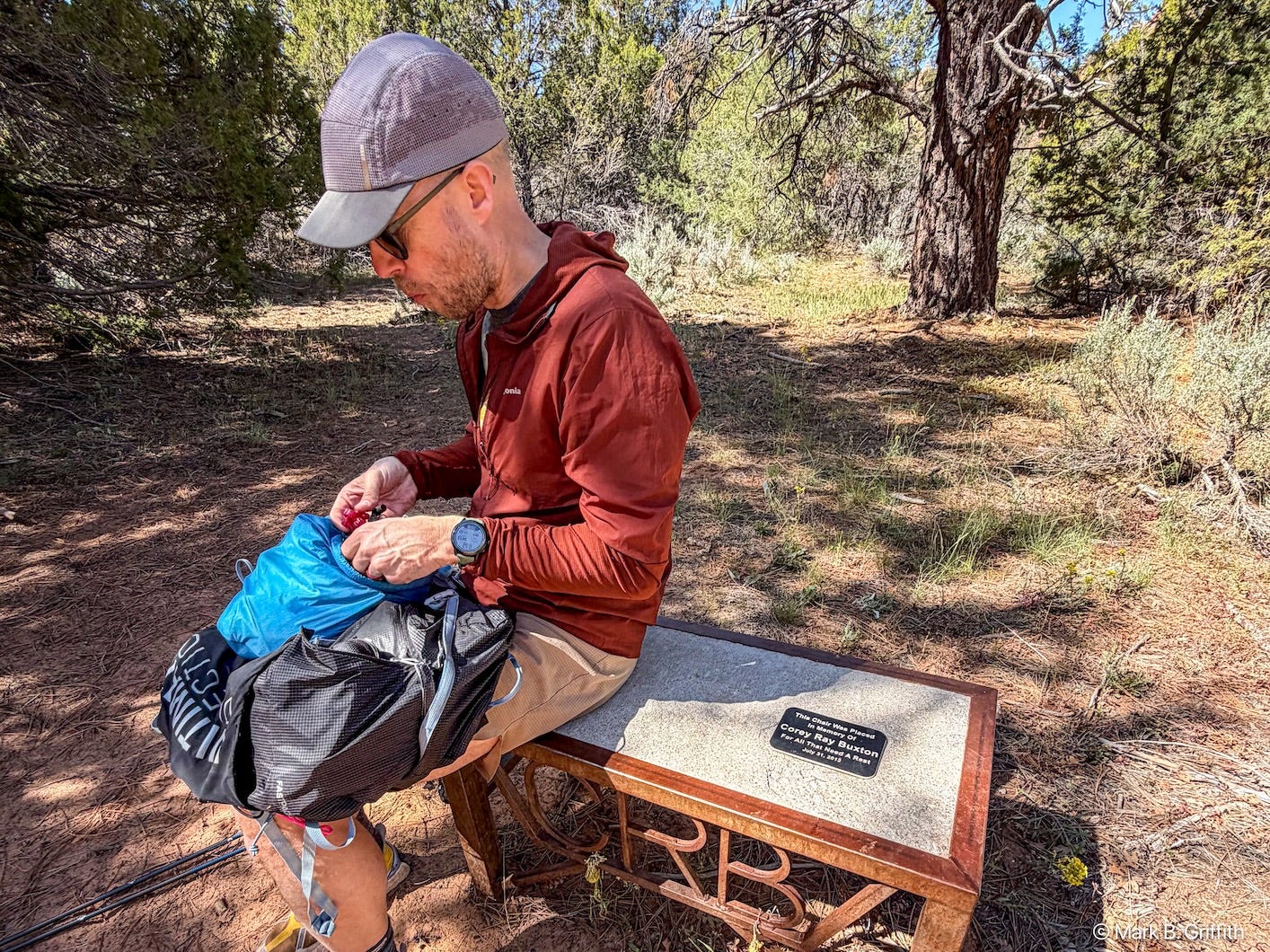
Checking in on my body - at this point - my left foot was starting to have the metatarsal nerve pain - that felt like shooting pain - but it was only like a 3 out of 10. And around mile 11 I started to feel some hot spot chaffing in between my thunder thighs. At mile 14 we reached the Hop Valley trail head and a bathroom and a road! (This would be a place where you could cache water if you got someone to make the 13 mile drive up from Virgin Utah). We stopped to use the facilities - and I loosened my left shoe - which immediately provided relief from the pain. A bathroom examination revealed that my chaffing was the result of a small hole starting to wear through my Path Projects liners - which was causing a hot spot. I wear these liners every day on my runs and wear and tear is a normal part of usage. Digging into my trusty first aid kit I cut off a long piece of Medical Surgical Tape - which is thin and soft and has an adhesive backing and I applied it to the inside of my thigh; I cut an extra piece of tape in case I had to reapply (I did once more with Seth’s help) and that pretty much solved the chaffing issue. Seth applied a couple of patches to his heels and we carried on.
Wildcat Canyon to White Rim (Mile 14-22.5)
Immediately after you cross the road the trail switches to a short bit of slick rock before you cross over a broad grassy field on a 3 mile connector trail that drops you into the Wildcat Canyon trail. This was one of my favorite sections of the trail that passes through a beautiful mature ponderosa pine forest with beautiful green grass. There is a gradual climb of 600 vertical feet over 3 miles. Somewhere along the climb as we passed through the forest - my foot continued to cramp with nerve pain that shot up to 3 to 5 out of 10 and I sat down to loosen my shoe again and to tape up my thigh to stave off the chaffing. Seth had some boiled potatoes and gave me one. I told him I would start walking - as his walking pace is faster than mine and I knew he’d catch up.
The trail then starts to traverse a deep canyon above Blue Creek and just as you loop around the end of the canyon to start the climb up to the White Rim - at mile 21 there is a small stand of aspens and a gurgling spring flowing between the rocks. This is Wildcat Springs, the ranger had informed us when Seth picked up our permit that the spring was flowing. Again we drank our fill - and filled up our bottles, this time I only took two liters (1 being full of Scratch). Seth caught up to me here and again I left him to refill while I tromped up the last mile to the junction of the White Rim trail - this was our high point of elevation 7400 ft above sea level.
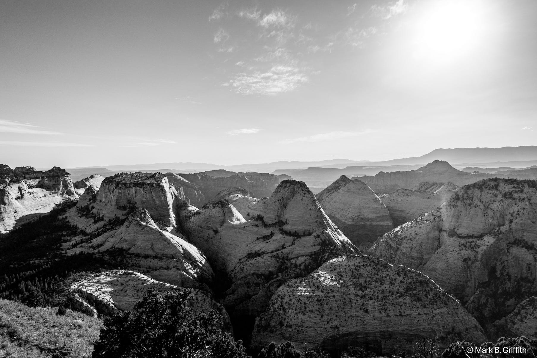
White Rim to The Lodge (Mile 22.5-38.5)
The first four miles is on the rim - but since your set back from the edge there are no real views, then you drop down and then up and down the high ridge - finally at 30 miles you are really on the edge of the rim and you have views off into the distant white topped canyons from whence the rim gets its name. In this section I had loosened my shoe a couple of times as the left foot nerve pain flared up. Eventually the pain spiked to 6 and then 7 and sometimes 8/9 - enough that I audibly groaned with each step. I had had tired hurt feet before - in particular on my Issy Alps 100, but this was by far the worst pain I’d ever experienced on the trail. I stopped and loosened my shoe one last time - to where it was almost entirely just open near the toes and sinched at the top of the tongue. Eventually the pain subsided to just a 2 or 3 out of 10 but with a couple of steep climbs and the pain - I was reduced to a repetitive focused state of step, poles, step poles, ragged breath : over and over again. Nothing else mattered; no other thought was present but just that and I’d often find myself just staring at the ground as I marched along. Every once and a while I would break out of my zone and remember my mantra and lift my eyes and take in the scenery around me. The top of the rim was a mix of large ponderosa pines and open plains of manzanita bushes that were dotted by dark spires of pines shattered and burnt by lightning. At times I felt flushed and like if I laid down that I’d break out into a fever and sweats, but I did not stop and carried on.
Eventually as we got towards the end of the rim and neared Cabin Spring (mile 32.7) my feet (both) were now just hurting from the long day - like a 2 or 3 out of 10. Even if we’d had gas in the tank to try to run at all along the rim, the wheels had fallen off. We took the wrong side trail for a short bit and I noticed the spring was down the hill and we had to back track and we were just so tired and ready to be done. Seth was not in the mood and did not want to stop. I was out of water but he had a liter left and gave me half.

It was now 7:30 pm. When we started 13 hours before at 6:30 am - we optimistically thought that we’d be done for sure by 6:30 pm, but the sand, the fatigue and the stops at springs and sitting down for some food had put us on the edge of the White Rim well past 6:30. We had only 5 miles to go - which dropped 2400 vertical feet. Under “normal” conditions - with gravity on your side - IF you have legs left you can descend at a faster pace. However by this time Seth’s legs were not up descending, each step down he’d groan as his knees gave out with each step. We made the dramatic descent down the White Rim and then traversed toward Scouts Lookout - just below Angels Landing. The sun went down at 8:18 and by 9pm the darkness over took us.
Of course we had left our headlamps at the car. So we pulled out our phones and turned on their flashlights. As we passed Scouts Lookout the trail turned to pavement - and the very steep Walters Wiggles zig zags straight down the cliff face with 21 switch backs that loose 260 feet in .2 miles for a 25% grade. This grade really caused Seth to groan with each step. He later said he wanted to stop and yell swear words at the trail. As we descended I had developed a raspy cough, likely from all the ragged breathing. We were worn down to the bone. When you are pushed to what you think is the limit and yet the only option is forward. There is no quitting, no DNF because there is nowhere to go; no one to pick you up, no helicopter to lift you out, no zip line to to take you down because your in the middle of the wilderness. The only way out is through. And when literally every foot step hurts and in the darkness the trail goes on and on - you just have to keep putting one foot in front of another and just keep going until you reach the end.

We descended down the trail cut out of the cliff - and the nearly full moon lit up the valley below. We finally reached the river - and then finally we reached the bridge - that crossed the Virgin river and trail was done. We were on the road and yet we still had ¾ of a mile to get to the Lodge. We arrived finally at 10:15 pm. The restaurant had closed at 9 pm. But it didn’t really matter because a well executed ultra is not only a feat of ultra endurance but also ultra eating. When was the last time you ate for 15 hours straight? By the end I had sores on my tongue from all the sugar I’d consumed over the course of 3700 calories. I wasn’t really hungry. At the front desk attendant got our bags and checked us in - I went to the drinking fountain and sucked down a lot of water. We trundled off to our room and I sat down in the shower and washed off the sweat and the grime. I got under the covers that had been jack hammered under the mattress and after tearing at them to give my tired feet some room I fell asleep hard and didn’t wake up once to go pee - a sure sign that I was still dehydrated.
Lessons Learned & The Aftermath
First of all - thankfully - my quad didn’t bother me at all - so that injury ended up being “done” - though since returning home on the 4th day I went on a short recovery run and my quad had twinges again - so who knows. But on the traverse - the quad was fine.
Secondly - I was happy how food and water went.
Thirdly - we did run the flats and downs the first 7 miles - (until we hit sand) and I think we would have been better off if we had just started out with a brisk walk and walked the entire time - not pounded the legs with even easy running.
Fourth : I think wearing the Brooks Cascadia Pro was a mistake - they have a carbon fiber plate in them - which is designed when you run to spring back and give you an energy return - but when you walk 90% of the time - I think that plate exacerbated my already irritated metatarsal and contributed to the nerve pain. On that recovery run on day 4 - about 40 minutes into the run my left foot started hurting again - so it’s still irritated. Need to let it rehab and figure out how to strengthen and get it back to healthy.
Lastly : despite the pain and the fatigue - the trip was really great. The weather was perfect, the scenery was beautiful and company was grand. And 3 days after when Seth and I were talking we both said we’d like to give it another go. ;)
Strava route : https://www.strava.com/activities/18301428737
Photos on Flickr : https://flic.kr/s/aHBqjCSNPw
Thanks so much for the detailed story of your trip! I enjoyed reading about it so much. Congratulations to both of you on completing this quest!! Great reading. I ran/walked/ and limped it with you!
Loved reading this report, Mark. It’s inspiring, to be honest. Seeing those areas of Utah, even in much pain, must have really been special. Glad you and Seth were successful in the adventure and thanks for the detailed write up!